Children’s Wall Map of the United Kingdom and Ireland
124 kr.
124 kr.
Tirs., 6 maj - man., 12 maj
Sikker betaling
14 dages åbent køb
Sælges og leveres af
Adlibris
Produktbeskrivelse
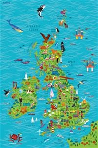
Colourful Illustrated Map of the United Kingdom and Ireland
This highly illustrated, rolled pictorial map is designed to take children on a journey of discovery around the United Kingdom and Ireland.
Stunning illustrations are used to depict themes such as national emblems, customs, food, birds, animals, buildings and sports to help younger readers gain an understanding of peoples around the world.
Illustrated by Steve Evans.
Varenr.
0418cb61-e2d2-4ee2-a843-594ffda9e93b
Children’s Wall Map of the United Kingdom and Ireland
124 kr.
124 kr.
Tirs., 6 maj - man., 12 maj
Sikker betaling
14 dages åbent køb
Sælges og leveres af
Adlibris
Lignende topsælgere

Bright Beauty Vanity Namira - make up spejl med belysning - hollywood spejl - schminke spejl med lys - hvid - dæmpbar med tre lystilstande
539 kr.
Tidligere laveste pris:
659 kr.

FENCHILIIN hollywood spejl makeup spejl med lys dæmpbar med tre lystilstande bordplade vægbeslag make up spejl med belysning hvid 58 x 46cm
589 kr.

Silikonetape / Plaster til Ar – Behandling af ar
69 kr.

FENCHILIIN Stor Hollywood Makeup Spejl med lys USB bordplade vægbeslag hvid 80 x 58 cm
961 kr.

Ørepuder til Bose QuietComfort - QC35/QC25/QC15/AE2 Hovedtelefoner Svart
69 kr.
")
G4 Halogenpærer / Stiftpærer - Halogen 10W (10-Pack)
69 kr.

Timer til Klasselokalet - 60 minutter
169 kr.

94 CM 3 X Plæneklipperknive til Husqvarna RIDER R213 R214 R215 R216 R316 R318 R320 AWD
265 kr.

FENCHILIIN Hollywood Makeup Spejl Med Lys 360° drejelig dæmpbar med tre lystilstande bordplade Spejl hvid 65 x 49 cm
439 kr.
Tidligere laveste pris:
521 kr.

Saphe One+ hastigheds- og trafikalarm
468 kr.
Anbefalede produkter

FENCHILIIN Hollywood makeup spejl med lys forstørrelse 360° drejelig bordplade hvid spejl 30 x 41 cm
279 kr.
Tidligere laveste pris:
331 kr.

2-i-1 elektrisk barbermaskine til kvinder, vandtæt, bikinitrimmer, dobbelt hoved, type-c Pink
170 kr.

vidaXL vægtstangs- og håndvægtssæt 30 kg
586 kr.

FENCHILIIN Hollywood stort makeup spejl med lamper bordplade vægmonteret hvid spejl med lys
479 kr.
Tidligere laveste pris:
539 kr.

Lader til iPhone - Hurtiglader - Adapter + Kabel 20W USB-C
79 kr.

Wii til HDMI Adapter 1080p Full-HD kompatibel til Nintendo
50 kr.

FENCHILIIN Stor Hollywood Makeup Spejl med lys Bluetooth Krystal Finish Bordplade Vægbeslag Hvid 80 x 58 cm Spejl
521 kr.
Tidligere laveste pris:
795 kr.
")
3-pak AGA AQVIA PET-flaske, 1L (hvid)
159 kr.

20-pak G4 halogenlamper 20W 12V - Varm hvid
99 kr.

Trådløs CarPlay-adapter 2025
279 kr.