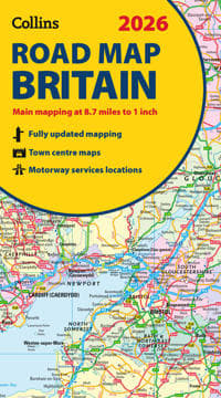
2026 Collins Road Map of Britain
134 kr.
134 kr.
Tidligere laveste pris:
137 kr.
Fre., 2 maj - ons., 7 maj
Sikker betaling
14 dages åbent køb
Sælges og leveres af
Adlibris
Produktbeskrivelse
Full-colour, double-sided road map of Great Britain at a scale of 8.7 miles to 1 inch. Northern England, Scotland and the Isle of Man are on one side with Southern England and Wales on the other.
With its easily identifiable counties and unitary authorities,this map is ideal for business users but it is also perfect for tourists for route planning.
Main features:
- Fully updated
- Counties and local council areas shown in colour
- Clear, detailed road network
- Town and city names, rivers and canals are clearly shown
- 16 city/town centre street plans
- Index to place names
- Mileage chart
- Car ferry routes
- Key in English, French and German
Varenr.
204d3f34-f155-536e-9bfa-b04ac33a4233
2026 Collins Road Map of Britain
134 kr.
134 kr.
Tidligere laveste pris:
137 kr.
Fre., 2 maj - ons., 7 maj
Sikker betaling
14 dages åbent køb
Sælges og leveres af
Adlibris
Lignende topsælgere

Bright Beauty Vanity Namira - make up spejl med belysning - hollywood spejl - schminke spejl med lys - hvid - dæmpbar med tre lystilstande
539 kr.
Tidligere laveste pris:
659 kr.
")
G4 Halogenpærer / Stiftpærer - Halogen 10W (10-Pack)
69 kr.

Timer til Klasselokalet - 60 minutter
169 kr.

Ørepuder til Bose QuietComfort - QC35/QC25/QC15/AE2 Hovedtelefoner Svart
69 kr.

FENCHILIIN hollywood spejl makeup spejl med lys dæmpbar med tre lystilstande bordplade vægbeslag make up spejl med belysning hvid 58 x 46cm
571 kr.

FENCHILIIN Hollywood Makeup Spejl Med Lys 360° drejelig dæmpbar med tre lystilstande bordplade Spejl hvid 65 x 49 cm
439 kr.
Tidligere laveste pris:
521 kr.

PS4 Handkontroll Trådlös DoubleShock
189 kr.

FENCHILIIN Stor Hollywood Makeup Spejl med lys USB bordplade vægbeslag hvid 80 x 58 cm
961 kr.
Tidligere laveste pris:
982 kr.

Wii til HDMI Adapter 1080p Full-HD kompatibel til Nintendo
50 kr.

Silikonetape / Plaster til Ar – Behandling af ar
69 kr.
Anbefalede produkter

42V 2A Hurtigoplader batterilader til el-scooter elcykel batterilader
115 kr.
Tidligere laveste pris:
128 kr.

FENCHILIIN Hollywood Makeup Spejl med lys Bluetooth Table Top vægbeslag hvid 58 x 46 cm
585 kr.
Tidligere laveste pris:
662 kr.

FENCHILIIN Hollywood makeup spejl med lys forstørrelse 360° drejelig bordplade hvid spejl 30 x 41 cm
331 kr.
Tidligere laveste pris:
391 kr.

FENCHILIIN Hollywood stort makeup spejl med lamper bordplade vægmonteret hvid spejl med lys
479 kr.
Tidligere laveste pris:
539 kr.

Universal 250 m afgrænsningskabel til robotplæneklippere + 800 pløkker
397 kr.
Tidligere laveste pris:
555 kr.

RCA AV till HDMI Converter / Adapter 1080P Universal White
79 kr.

Universal 250 m afgrænsningskabel til robotplæneklippere
303 kr.

Ersättningsfjärrkontroll för Chromecast Google TV G9N9N
79 kr.
Tidligere laveste pris:
89 kr.

20-pak G4 halogenlamper 20W 12V - Varm hvid
99 kr.

Lader til iPhone - Hurtiglader - Adapter + Kabel 20W USB-C 3-Pack iPhone
179 kr.